


History of Organization

Ramganga Dam
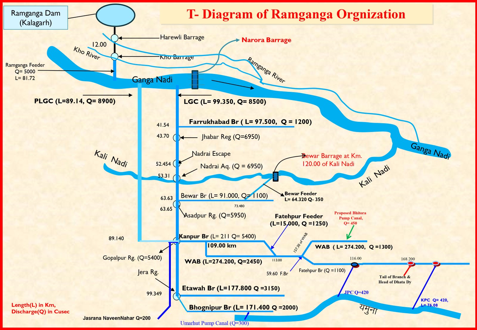
Ramganga dam is built on Ramganga river in district Pauri Garhwal, Kalagarh, in which water is stored, the drainage of this accumulated water is done through the powerhouse built on the 'tow' of Ramganga dam as needed for irrigation of the districts of the eastern region of the state.
The dam is part of the Ramganga Multipurpose Project - an irrigation and hydroelectric project. The capacity of Kalagarh Dam is 365.300 m, out of which 85 percent water is used for irrigation. Of the water received for irrigation, 72 percent is used for rabi and 28 percent for kharif crops, it supports a 198 MW power station and provides water to irrigate 57,500 hectares (142,086 acres) of agricultural land . In addition, it provides flood control and recreation. The construction of the dam started in 1961 and was completed in 1974. The three generators at the power station were commissioned in December 1975, November 1976 and March 1977.
The water received from Ramganga dam is used at Harewali barrage in district Bijnor after flowing in Ramganga river about 26 kms from Kalagarh. 5350 cusecs of water from Harewali Barrage is re-injected into the river through Ramganga Feeder Canal and is picked up at Kho-barrage constructed on Kho River in district Bijnor, from where 250 cusecs of water through sub-feeder canal to Ramganga Canal System in districts Moradabad, Amroha and Bijnor. is given for irrigation. Authorized 5100 cusecs of water is put into Waha Nallah near village Sherpur in district Amroha through 81.716 km long feeder canal. After walking about 16 km from here, near Tigri Ghat, this water joins the river Ganga, and the water obtained is used for the canals and e-low maintenance of Ramganga organization.


Jeevandaini Ganga
The main branch of river Ganga is Bhagirathi, which originates from the Gangotri glacier at a place named Gaumukh in Himalayas in district Garhwal. Bhagirathi and Alaknanda rivers meet at Devprayag, the life-giving Ganga flows from the union of these two rivers. The Ganga touches the plains at Haridwar via Rishikesh after covering a 200 km hilly path. Traveling about 800 km from Haridwar, it reaches Prayagraj via Garhmukteshwar, Soron, Farrukhabad, Kannauj, Bithoor, Kanpur and after covering a total distance of 2525 km, joins the Bay of Bengal. In Murshidabad district of West Bengal, it splits into Bhagirathi and Padma rivers.


Details of circle and section of the organization
| Sl.No. | Circle Name | Division Name |
|---|---|---|
| 1 | Superintending Engineer Irrigation Works Circle, Aligarh |
Executive Engineer Narrora Division Lower Ganga Canal Aligarh
Executive Engineer Irrigation Division Etah
Executive Engineer Irrigation Division Kasganj
|
| 2 | Superintending Engineer Irrigation Works Circle, Etawah |
Executive Engineer Irrigation Construction Division Firozabad
Executive Engineer Irrigation Division Auraiya
Executive Engineer Etawah Division Lower Ganga Canal Etawah
Executive Engineer Bhognipur Division Lower Ganga Canal Etawah
|
| 3 | Superintending Engineer Irrigation Works Circle, Kanpur |
Executive Engineer Irrigation Division Kanpur Dehat
Executive Engineer Irrigation Division Fatehpur
Executive Engineer Fatehpur Division Lower Ganga Canal Fatehpur
Executive Engineer Irrigation Division Kaushambi
Executive Engineer Barrage Construction Division 2 Kanpur
|
| 4 | Superintending Engineer 2nd Circle Irrigation Works Kanpur |
Executive Engineer Kanpur Division Lower Ganga Canal Kanpur
Executive Engineer Irrigation Division Kannauj
Executive Engineer Irrigation Division Farrukhabad
Executive Engineer Mainpuri Division Lower Ganga Canal Mainpuri
|
Irrigation System – Description of Canal Systems
Water supply for non-agricultural purposes
| Sl.No. | Sanyantr name | Amount of water | Source and chain of water availability |
|---|---|---|---|
| 1 | Narora Atomic Power Sanyantr 2x660 units | 50 Cusec | Water supply through the supply channel originating from the right bank in the upstream of Narora barrage. |
| 2 | Panki Power House | 18.40 Cusec | Kanpur Branch Km 206.750 Right Track |
| 3 | Ordinance Factory Kanpur | 08 Cusec | Kanpur Branch Km 210.31 Left Track |
| 4 | Kanpur Fertilizer Kanpur | 15 Cusec | Kanpur Branch Km 211.10 Right Track |
| 5 | NTPC Dibiyapur | 13 Cusec | Mangalpur Raj0 Km 3.880 Left Track |
| 6 | GAIL PATA Sanyantr | 17 Cusec | Buddana Rajbaha Km 17.200 Right Track |
| 7 | Field Gun Factory Kanpur | 05 Cusec | Kanpur Branch Km 209.34 Right Track |
| 8 | Proposed for Jawaharpur Thermal Power Sanyantr | 38 Cusec | Beaver branch from Km 22.00 |
| 9 | For Ghatampur Thermal Power Sanyantr | 80 Cusec | Fatehpur Branch Km 17.100 Right Bank |
Water supply for drinking water
| Sl.No. | Venue Name | Amount of water | Source and chain of water availability |
|---|---|---|---|
| 1 | District Kanpur Nagar (Benajhabar) | 21 Cusec | Km 209.79 right track of Kanpur Branch |
| 2 | Gujaini Water Works | 10 Cusec | Km 0.400 Left Track of Fatehpur Feeder |
| 3 | Drinking water to Kanpur Nagar | 80 Cusec | Lavkush Ganga Barrage from right bank of Kanpur |
| 4 | District Firozabad City | 50 Cusec | From Km 25.200 of Jasrana Naveen Canal |
| 5 | District Firozabad Rural Drinking Water Scheme- Proposed | 245 Cusec | Left bank of lower ganges canal |
| 6 | Drinking water to district Unnao Shuklaganj - proposed | 34 Cusec | From the left bank of Lavkush Ganga Barrage |